


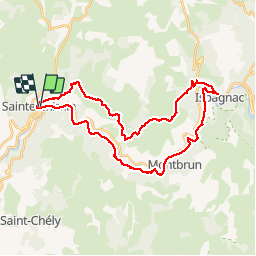
Saint-Enimie - Ispagnac (boucle)

micheldutilleul
User

Length
37 km

Max alt
968 m

Uphill gradient
1065 m
Km-Effort
51 km

Min alt
464 m

Downhill gradient
1072 m
Boucle
Yes
Creation date :
2018-06-26 12:51:25.291
Updated on :
2018-06-26 12:51:25.291
10h02
Difficulty : Difficult

FREE GPS app for hiking
 SityTrail
IGN / Geographical institutes
SityTrail Plus
The world is yours!
About
Trail Walking of 37 km to be discovered at Occitania, Lozère, Gorges du Tarn Causses. This trail is proposed by micheldutilleul.
Positioning
Country:
France
Region :
Occitania
Department/Province :
Lozère
Municipality :
Gorges du Tarn Causses
Location:
Sainte-Enimie
Start:(Dec)
Start:(UTM)
532828 ; 4912559 (31T) N.
Comments